Wednesday, October 18, 2017
Day 53 Clayburn Creek
Finally, Oct. 18, 2017 I am posting this on the actual day today! It rained and rained and rained all day today, and I thought perhaps I was not going to get in a walk at all. But it stopped in the evening, so I went out for a 3.8 km late evening walk along Oswego, Belleville, Government Streets and Dallas Road here in James Bay, This brings the total distance over the 53 days to 383.0 km. Virtually I am near Clayburn Creek, just outside Abbotsford on the Abbotsford Discovery Trail.
Day 52 Ridgedale
Even though windy and definitely feeling like fall, a good day for walking, and I completed 7.7 km more today, bringing the total distance over the 52 days of the walk to 379.2 km. On the virtual tour walk, I am on the Abbotsford Discovery Trail, near Ridgedale, just a bit outside Abbotsford.
Day 51 Riverside
So, I got a few days behind again in my posting - it's easier to be regular in walking than in posting! Today was a good day for walking, as I completed 7.2 km plus 4.5 km for an 11.7 km total for the day. This brings the total distance over the 51 days of the walk to 371.5 km. On the virtual tour walk, I am now well along the Abbotsford Discovery Trail, near Riverside, just a bit outside Abbotsford.
Day 50: 7.2 km per day average so far
Alas, this was one of the few days that I did not get any walking in, so my total distance over the 50 days of the walk is 359.8 km, the same as yesterday 😒. For the first 50 days of the walk I have averaged 7.2 km per day. That is a bit less than the 8.0 km I was aiming for, but overall not bad I guess. Of course the weather is turning less favourable the next few months here, so it may be a bit more challenging to get in the long walks. I have not actually worked out the total distance along The Great Trail route I am doing from Victoria, BC to Sackville, NB, but I think I am on track to complete it by spring 2022, my goal. #SeeYouIn22!
Sunday, October 15, 2017
Day 49 Mount Johnson
Almost caught up in posting - this is was for yesterday! On day 49 of the walk (Oct. 14, 2017) I added another 7.7 km (the basic loop along Dallas Road waterfront park, through length of Beacon Hill Park, via Thunderbird Park, and then a bit of James Bay streets for 5.8 km, plus a short evening loop adding 1.9 km more), bringing the total distance over the 49 days of the walk to 359.8 km. On the virtual tour walk, I have started the Abbotsford Discovery Trail, and will continue on that for a number of days. Today I am near Mount Johnson. Tomorrow (well today really) will be day 50, and I plan to compute the average distance per day for the first 50 days.
Day 48 Langley Township Trail
On day 48 of the walk (Oct. 13, 2017) I added another 7.8 km, bringing the total distance over the 48 days of the walk to 352.1 km. On the virtual tour walk, I have just finished the Langley Township Trail past Fort Langley, BC.
Day 47 Fort Langley
On day 47 of the walk (Oct. 12, 2017) I added another 8.3 km through walks in Victoria, BC, bringing the total distance over the 47 days of the walk to 324.7 km. On the virtual tour walk, I moved from the Pitt River Greenway onto the Langley Township Trail, in the area of Fort Langley, BC. The part of the trail I am just starting in the days ahead is shown on this Great Trail map.


Day 46 Pitt River Greenway
I am almost caught up with recording here the details on the actual day I do the walk! I have made a pre New Year's resolution to not get behind again! On day 46 of the walk (Oct. 11, 2017) I added another 7.8 km, bringing the total distance over the 46 days of the walk to 316.4 km. On the virtual tour walk, I am on the Pitt River Greenway, which takes me along dykes along the Fraser and Pitt Rivers. Fall comes rapidly here in British Columbia, and my walks in Victoria are much cooler than they were just a few weeks ago. So far I have kept this activity just to myself, my immediate family members, and my doctor, but I think I will do a general announcement on my social media before too long. I wanted to be sure that I was keeping up with it before doing that.
Day 45 Pitt River
On day 45 of the walk (Oct. 10, 2017) I passed the first 300 km by adding 9.2 km, bringing the total distance over the 45 days of the walk to 308.6 km, On the virtual tour walk, I am just past Pitt River, BC.
Day 44 Hockaday Nestor, BC
On day 44 of the walk (Oct. 9, 2017 which among other things is the anniversary of the Peekskill meteorite fall!) I added 5.8 km, bringing the total distance over the 44 days of the walk to 299.4 km (so close to the first 300 km!) On the virtual tour walk, I am east of Port Moody, BC. This is taking me past some interesting placenames including City Centre (even though we are far from Vancouver city centre!) and Hockaday Nestor (in the modern world a place name with the o changed to a might be more common!).


Day 43 Eagle Ridge
On day 43 of the walk (Oct. 8, 2017) I added 9.2 km, bringing the total distance over the 43 days of the walk to 293.6 km. On the virtual tour walk, this brings me east of Port Moody, BC in the Eagle Ridge area (see map from yesterday's post). My real walk continues to be the usual loops around James Bay, Victoria, BC.
Day 42 Port Moody
On day 42 of the walk (Oct. 7, 2017) I added 7.8 km, bringing the total distance over the 42 days of the walk to 284.4 km. On the virtual tour walk, this brings me into Port Moody, BC. My real walk continues to be the usual loops around James Bay, Victoria, BC, including the Dallas Road walk, Beacon Hill Park, and a bit of the Inner Harbour walk.


Day 41 Vancouver
On day 41 of the walk (Oct. 6, 2017) I added 11.0 km (a bit tired after yesterday's longer than usual walk!), bringing the total distance over the 41 days of the walk to 276.6 km. On the virtual tour walk, this took me further along the east side of Vancouver, BC. You can follow along on, with my route on The Great Trail marked in green.


Day 40 False Creek
On day 40 of the walk (Oct. 5, 2017) I added 6.9 km (a bit tired after yesterday's longer than usual walk!), bringing the total distance over the 40 days of the walk to 265.6 km. On the virtual tour walk, this took me along some of the best known scenes from Vancouver, BC along the False Creek area past Granville Market and along to the region with BC Place and Science World. If you have visited Vancouver, you have probably visited this area. It includes beautiful harbour views, city scapes, in a varied and vibrant community.
Day 39 Stanley Park, Vancouver, BC
On day 39 of the walk (Oct. 4, 2017) I added 11.1 km, bringing the total distance over the 39 days of the walk to 258.7 km. On the virtual tour walk, this took me to the end of the beautiful loop walk around Stanley Park in Vancouver, BC. In terms of the real walk, instead of my usual loops around the James Bay region of Victoria, BC, I walked through downtown and across the Johnson St. bridge to Victoria West. There I picked up the trail along the harbour, taking it all the way to the houseboat community at the end of the trail in Esquimalt. I had read that the views were spectacular from this side, better than the more popular inner harbour walk in James Bay. I had been sceptical, but after doing the walk I agree. Incredible walk especially in the last part! I will later add some photos to this posting. So on Oct. 4 both my real walk and my virtual walk were on incredibly beautiful harbour trails, one in Victoria region and the other in Vancouver region!
Day 38 Stanley Park, Vancouver, BC
On day 38 of the walk (Oct. 3, 2017) I added 7.8 km, bringing the total distance over the 38 days of the walk to 247.6 km. On the virtual tour walk, today's distance takes me into the early part of the beautiful loop walk around Stanley Park in Vancouver, BC.
Day 37 North Vancuver
On day 37 of the walk (Oct. 2, 2017) I added 7.7 km, bringing the total distance over the 37 days of the walk to 239.8 km. On the virtual tour walk, today's distance takes me from near Canyon Heights into North Vancouver. Will be crossing into Stanley Park tomorrow! #SeeYouIn22
The route I am taking on The Great Trail is marked on the map below.
The route I am taking on The Great Trail is marked on the map below.
Day 36 Sentinel Hill and Canyon Heights, BC
On day 36 of the walk (Oct. 1, 2017) I added 9.1 km, bringing the total distance over the 36 days of the walk to 232.1 km. Now feeling that I am getting back to my regular routine of a good distance walking each day, mainly in the beautiful James Bay area. On the virtual tour walk, today's distance takes me from near West Bay, BC through Sentinel Hill almost to Canyon Heights.
Day 35 West Bay, BC
On day 35 of the walk (Sept. 30, 2017) I added 7.8 km, bringing the total distance over the 35 days of the walk to 223.0 km. This takes me from the Horseshoe Bay ferry terminal to the community of West Bay, BC.
Saturday, October 14, 2017
Days 33-34 Nanaimo Ferry Terminal
Over days 33 and 34 (Sept. 28-29, 2017) I added 11.6 km, bringing the total distance over the 34 days of the walk to 215.2 km. This brings me to the BC Ferries terminal in the city of Nanaimo, so now I am virtually on the ferry to on mainland British Columbia. The rate of progress has been slower the last few weeks, but now I am back to a higher daily rate again, and hope to achieve #SeeYouIn22.
Days 29-30 Nanaimo
So my walk has now passed the first month! Over Sept 24 through Sept 27 (days 29 through 32 of the walk) I added 25.3 km, which brings the total distance over the 32 days of the walk to 203.6 km. This brings me to the outskirts of the city of Nanaimo. Will be at the ferry terminal in Nanaimo soon!
Days 28
Today (Sept. 23, 2017 which is day 28 of the virtual walk) I added another 9.6 km of walking around James Bay, bringing the total distance travelled in 28 days to 178.3 km. I discovered that there is, apparently, a short break in The Great Trail just south of Nanaimo requiring a long diversion 😕, that I am now on.
Days 26-27 Oyster Bay, BC
On Sept. 21 and 22 combined, days 26 and 27 of walk, I added 11.5 km which brings the total distance for the 27 days to 168.7 km. This brings me past the community of Oyster Bay, BC.
Day 25 Ladysmith, BC
On Sept 20, 2017, which is day 25 of the walk, I added 5.4 km which brings me to a total distance of 157.2 km over the 21 days. This brings me to the beautiful town of Ladysmith, BC. Maybe I will drop in to the wonderful bakery and have a treat! 😃
Days 22-24 Chemainus, BC
On days 22 through 24 of the walk (Sept. 17-19 inclusive) I added a modest 13.4 km (Sept 17 1.9 km, Sept 18 3.8 km and Sept 10 7.7 km). This brings the total distance walked over 24 days to 151.8 km, which virtually brings me to the interesting community of Chemainus, BC.
Friday, October 13, 2017
Days 18-21
On Sept. 13 through 16 (days 18-21 inclusive) I added 17.1 km (Sept. 18 6.2 km, Sept 12 5.1 km, Sept. 15 4.8 km and Sept. 16 1.0 km) while walking in the area of Jordan River, bringing the total distance to 138.4 km over the 21 days. On my virtual The Great Trail trek this took me through Hayward, Somenos, and past Westholme BC
Day 17 Hillcrest, BC
On Sept 12 we did the Botanical Bay and Botanical Beach loop trail just past Port Renfrew - a very beautiful walk, even on the foggy day! This added 2.8 km for my virtual trip across Canada, and another 1.5 km added in other walking that day.
Therefore, after Day 17 my total distance walked was 121.3 km, which took me past Hillcrest, BC on my way toward Hayward.
Days 11 through 16 Lake Cowichan, Paldi
During these days we were at the CRD camping area at Jordan River. This is a pretty beautiful place right on the ocean, and we had a great time. It was not suited to long distance walking though, and my usual daily hikes to the other end of Jordan River village, or beach walks in one direction or the other. Here are the details:
Sept. 6 1.0 km
Sept 7 3.4 km
Sept 8 5.4 km
Sept 9 2.9 km
Sept 10 7.1 km
Sept.11 6.3 km
Total 26.1 km
Therefore, after 16 days (Sept. 6-11, 2017), 117.0 km total distance, which takes us from Cowichan River Provincial Park past Lake Cowichan and past Haldi.
Sept. 6 1.0 km
Sept 7 3.4 km
Sept 8 5.4 km
Sept 9 2.9 km
Sept 10 7.1 km
Sept.11 6.3 km
Total 26.1 km
Therefore, after 16 days (Sept. 6-11, 2017), 117.0 km total distance, which takes us from Cowichan River Provincial Park past Lake Cowichan and past Haldi.
Days 9, 10 Deerholme, BC
Sorry followers, due to a variety of factors my walking has slowed a bit, and even the walking I did was not updated here. I will try to get caught up, and then get back to daily updates.
This post covers Sept. 4 and 5 (days 9 and 10) during which my walking in James Bay, Victoria added 16.8 km (over the two days 11.1 km on Sept 4 and 8.6 km on Sept 5) to bring the total to 90.9 km. This brings my virtual position on The Great Trail to just past Deerholme almost to Cowichan Provincial Park.
More updates soon!
After 10 days (Sept. 5, 2017), 90.9 km total distance, just past Irving Creek on Malahat Mountain.
Monday, September 4, 2017
Day 8 Past Koksilah River (Malahat Mountain)
I added 11.1 km over my two walks today, to bring the total distance travelled to 71.2 km. I am still on Malahat Mountain, now having passed Koksilah River and on my way toward Deerholme.
Today the Classic Boat Festival was happening in Victoria, so I saw a procession of boats going out when I started my walk on the outer coast, and then a stream of boats returning to harbour when I finished my walk at the Inner Harbour.
After 8 days (Sept. 3, 2017), 71.2 km total distance, just past Irving Creek on Malahat Mountain.
Saturday, September 2, 2017
Day 7 McGee Creek, Malahat Mountain
Still working on the long trail up Malahat Mountain. Added a total of 7.9 km today, which brings the total distance walked to 60.1 km. On Malahat Mountain I am well past McGee Creek. This is a beautiful area with trestle bridges over creeks and rivers. I wished I was really there, and not just virtually! Maybe some day!
After 7 days (Sept. 2, 2017), 60.1 km total distance, just past Irving Creek on Malahat Mountain.
Day 6 Irving Creek (Malahat Mountain)
Today saw 9.1 km added, bringing the total to 52.2 km. Still a long way to go on Malahat Mountain before I reach Shawnigan Lake.
After 6 days (Sept. 1, 2017), 52.2 km total distance, just past Irving Creek on Malahat Mountain.
After 6 days (Sept. 1, 2017), 52.2 km total distance, just past Irving Creek on Malahat Mountain.
Friday, September 1, 2017
Day 5 Malahat Mountain
On day 5 (Aug. 31, 2017) I did my two standard loops in James Bay, adding 7.4 km (total distance now 43.1 km over the 5 days). This places me along the forested trail in Malahat Mountain (still long way to go up the mountain, though!).
I thought I would share with you the route I most usually take each day. I start with our home in central James Bay, and head to the outer coast along Dallas Road. The walk along the coast is beautiful! Almost always there is a range of sea traffic to watch, ranging from small pleasure boats to large ships. I take the option to go down to the lower path beside the water for a portion of this part of the trail.
I continue along this path until I reach Cook St. where I cross Dallas Road. I then take a diagonal path through Beacon Hill Park, the first part of which is beautifully forested. Further along I pass the gardens and ponds. I then divert and take the gravel path through the high point of Beacon Hill park that is nearest downtown.
While only a few steps away from the more gardened parts, the rocky outcrops and stunted trees make this seem like a different world. I emerge on Southgate street across from the historic St. Ann's Academy National Historic Site. I cross Douglas St. and always stop to wave at .
A few steps further on I pass through Thunderbird Park, on the edge of the Royal British Columbia Museum. Even though near two busy streets, this set of totems offers a peaceful way to appreciate the first nations who lived here for thousands and thousands of years.
Now I am at the Inner Harbour, with the Empress behind me, the harbour on my right and the British Columbia legislature on my left. Together these represent the most photographed scenes in Victoria, BC, although I like the quieter, less busy parts of my walk.
At this point I either continue along Inner Harbout to Fisherman's Wharf, if ready for a longer walk, or take a left up Menzies St. if taking the basic 5.5 km loop. I will describe the longer loop option, and some photos of the Inner Harbour walk, in a later posting.
The Menzies St. option is usually shaded on one side, and passes by the Capital Park project, phase one of which is nearing completion. It will include a new public library branch for us 😃.
Soon I am at the main corner of businesses in James Bay, and home soon after. James Bay is the oldest European settlement north of San Francisco.
After 5 days (Aug. 31, 2017), 43.1 km total distance, Malahat Mountain.
Wednesday, August 30, 2017
Day 4 Wolf Hill (near Goldstream) BC
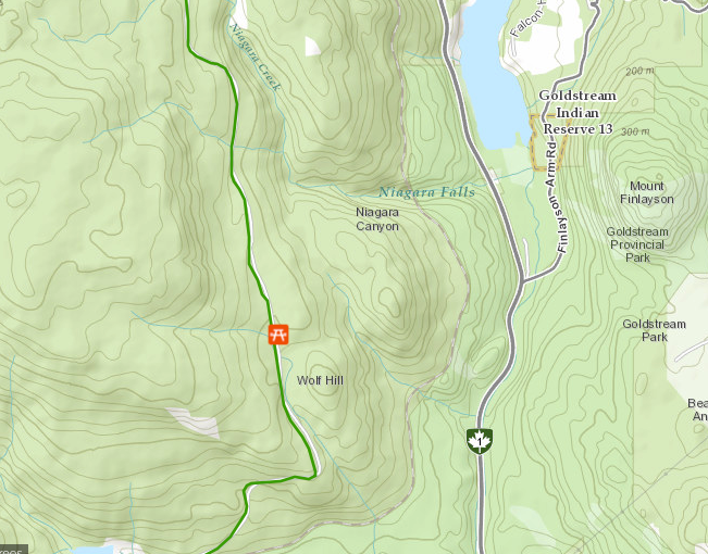 |
| The Great Trail (green) is to the left of Golstream Park. |
Rather than my normal routes in James Bay, I had the opportunity today to walk much of my daily walk on The Great Trail in the Gorge area of Victoria, BC up to Uptown in Saanich and back. This was a beautiful walk, with interesting nature, ocean bay and artwork.
Today (Day 4) I added 9.7 km, bringing the total to 35.7 km.
Tuesday, August 29, 2017
Day 3 Langford, BC
Today I've added 7.4 km, bringing the total to 26.0 km. I am in the region of Langford, BC (virtually that is!). A warm but nice day for a walk in James Bay, with some bigger than normal waves on the outer harbour.
In my walk in James Bay today I walked by The Glenshiel, an independent living facility for seniors run as a non-profit organization. Recently I have learned about an amazing program where some of the residents have paddles with messages to cheer people who walk by. Today I got to wave to one of the residents with her paddle. If you are walking in the area, please do the same and spread the message. There is an article in the James Bay Beacon about to come out any day on the program (Win-Win Window!). Give it a read!
Day 3 I walked 7.4 km which took me from a starting point in View Royal to near Langford, BC. Total distance travelled so far 26.0 km.
 |
| The region I am in today near the city of Langford, BC. The green line shows The Great Trail. |
In my walk in James Bay today I walked by The Glenshiel, an independent living facility for seniors run as a non-profit organization. Recently I have learned about an amazing program where some of the residents have paddles with messages to cheer people who walk by. Today I got to wave to one of the residents with her paddle. If you are walking in the area, please do the same and spread the message. There is an article in the James Bay Beacon about to come out any day on the program (Win-Win Window!). Give it a read!
Day 3 I walked 7.4 km which took me from a starting point in View Royal to near Langford, BC. Total distance travelled so far 26.0 km.
Day 2 View Royal, BC and a slogan!

In the distance across the inlet from View Royal is the Fort Rodd National Historic site - it actually includes two historic sites, a fort and a lighthouse. It, along with all Canadian National Parks and Historic Sites, has free admission this year for Canada 150, so this year would be an ideal time to visit.

I shared the start of my virtual walking journey with my granddaughter yesterday, and she is keen to start her own walk. In case any of you reading this have started your own walk, why not mention it in the comments, and include a link if you have an online update.
The other bit of news, on my walk yesterday I thought of a slogan for my walk. As mentioned yesterday, while I am not setting a firm goal for either destination for time period, I am hoping to complete from Victoria, BC to Sackville, NB by May, 2022 (which will be my Mount Allison Class '72 50 year reunion). I am going to use the slogan #SeeYouIn22 for my walk (kind of a message to my Mount Allison and New Brunswick Friends).
Day 2 I walked 8.1 km which took me from a starting point in the Uptown region of Saanich, BC to the View Royal region of BC (approaching Langford, BC).
Sunday, August 27, 2017
The Idea and Day 1
I am a fan of The Great Trail (formerly called the Trans Canada Trail). As I write this the 22,000 km trail is 93% complete. Walking the trail enriches lives from coast to coast to coast. The trail inspires and brings Canadians together. I hope each of you have had the opportunity to explore parts of the trail near where you live.
I also love walking in the James Bay area of Victoria where I now live in retirement. With a mix of developed and natural coast, urban streets, the beautiful Beacon Hill Park, it offers incredible variety in a loop walk of an hour or so. Most days I spend at least an hour walking, sometimes more. I look forward to sharing my daily walks with you through this blog.
So the plan is to track the distance I walk each day, and to trace it out along The Great Trail, gradually working my way from west to east. I have started where I live in Victoria, BC and my goal is to make it to Sackville, NB, where I lived for most of my life. I plan to count only walking I do specifically for walking sake, that is not count walking I do to go to a store or do everyday things.
I realize this will take many years, and even if I don't make it all the way, it still will be fun! I deliberately am not setting a goal for how much I will walk each day, or how long it will take. It would be wonderful if I could complete it by May, 2022. That would correspond to my 50th year after graduation from Mount Allison University, and I plan to be there for the reunion so I could do the final walking actually in New Brunswick.
On this blog I will share a little bit both about where I am really walking (usually James Bay, Victoria, occasionally elsewhere) and what I have learned about where I am imagining walking. On the top right I will update what day I am on (I started this on August 27, 2017), the total distance I have walked, and the last community that I virtually visited.

For the starting day I got from Clover Point in Victoria, BC (within a couple of km from my home) to the Uptown region of Saanich, BC. The first part of today's route included the very beautiful section along the Dallas Road coastal path, then a portion of the David Foster Harbour Pathway, and then joined up with the Galloping Goose regional trail. You can see it (in green) on the map on the right. Click on the image to see it in higher resolution.
Thanks for coming along on my walk!
-Bob
Day 1 I walked 10.5 km which took me from a starting point at Clover Point to the Uptown region of Saanich, BC.
Subscribe to:
Posts (Atom)